Difference between revisions of "Radio Activities"
(→Scanner Icecast internet feed) |
|||
| Line 66: | Line 66: | ||
[[Image:Bl-adsb.jpg|none|thumb|300px|ADS-B receiver]] | [[Image:Bl-adsb.jpg|none|thumb|300px|ADS-B receiver]] | ||
| + | |||
| + | ==== Downloading aircraft data from our receiver ==== | ||
| + | To download aircraft data from our receiver, use a web browser and connect to the unit (only from within Bloominglabs: http://192.168.1.3 ). There is no login required. You can also use wget to download the full log (goes back about ~36 days): | ||
| + | <pre> | ||
| + | wget -O aircraft.log http://192.168.1.3/log.php?id=xxx | ||
| + | </pre> | ||
| + | |||
| + | The data you want are the lines with [mlat] tags in them, in this case A4E330 is the planes id: | ||
| + | <pre> | ||
| + | 2017-07-02 05:49:00 | [mlat][i] A4E330 | ||
| + | </pre> | ||
| + | |||
| + | Log dates are in UTC, so subtract 4 hours to convert all timestamps to EDT (or -5 hours for EST). | ||
| + | |||
| + | ==== Notes on data ==== | ||
| + | Our receiver regularly pulls in beacons from aircraft over 200 nautical miles away. Technically most of the aircraft data we receive are MLAT beacons (S-mode identifiers) which is different from ADS-B. MLAT signals are usually only receivable from the ground if the aircraft is above 5k-10k feet unless direct line-of-sight was obtained. The S-mode identifier is a 24-bit hex address unique to every aircraft. Not all aircraft have beacons, although after the year 2020 the FAA will require all aircraft to have some type of identifier. | ||
| + | |||
| + | The MLAT / S-mode / ICAO24 identifier will tie to a specific aircraft and tail number. Not all sites have a complete database, so multiple sources can be useful when looking up identifiers. These are handy to use: | ||
| + | * [https://www.flightradar24.com/data/aircraft https://www.flightradar24.com/data/aircraft] | ||
| + | * [http://www.airframes.org http://www.airframes.org] - Put the MLAT number in the "ICAO24 address" field | ||
| + | |||
| + | This site is very useful, you can do lookups here and also retrieve flight paths to see everywhere an aircraft has been logged: | ||
| + | * [http://www.ads-b.nl/index.php?pageno=9999 http://www.ads-b.nl/index.php?pageno=9999] | ||
| + | |||
| + | We only see occasional beacons from aircraft, so when the beacons pop-up behind it’s last known path, it means it was flying a circle around that area. The path just draws straight lines between beacon locations, so that can be somewhat misleading when a plane is circling an area. | ||
Revision as of 11:21, 10 August 2017
We have several antennas and radios available for several bands and projects. This page is here to help track these projects and let folks know what we are doing.
Contents |
Infrastructure
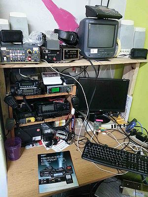
Radio Desk
This is a desk that has been setup in an out of the way area just for radio activites at Bloominglabs. The idea was to keep this semi-isolated so that it attracts less non-radio related cluter, currently it's in the corner of the kitchen area. This is also relatively close to the antennas for shorter coax runs and provides easy access to the grounding block demarco.
FCC licenced individuals are welcome to use our Ham radio gear. If you want to connect your rig to our antennas on a temporary basis that is fine too. If you want to setup any long term gear that's great, just let someone know that you have an interest and we'll help you get hooked up.
Radios
- Amateur Radio
- Yaesu FT-7800R dual band transceiver
- Yaesu FT-900 HF transceiver
- Radio Shack HTX-212, 2m transceiver
- Kenwood TK-705D 2m transceiver
- Other bands
- Radio Shack Sport CB
- RX only
- Uniden 996T Digital Scanner
- Realistic Pro-136 Scanner (sub 1GHz)
- Weather radio
Antennas
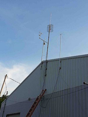
Our building has a 12 foot ceiling indoors and the peak of the roof line is at about 20 feet. We have a 17' mast which is approximately 13' feet above the peak of our roof. At the top is a dual-band 2m/440 ham antenna, then a WiFi dish is mounted just below that. We have another 10 foot mast with a discone on top mounted North of there for general scanning use, as well as other antennas.
- Mast 1 - Left-most
- Weather Station
- ADS-B airplane telemetry antenna
- room for one more antenna
- CB antenna mounted to side of building at the peak, no mast
- Mast 2 - peak is about 33'
- 2 meter pole antenna, top of antenna is at about 38'
- 24dBi dish for wifi mesh
- Mast 3 - peak is about 25'
- Discone for wide band receiving, LMR-400 coax for low loss
- We have a LNA for this antenna if we want to improve higher-frequency reception. Currently hooked up to the Uniden digital scanner.
- Mast 4 - pending
- Cushcraft R-6000 HF antenna
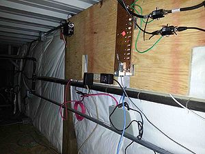
Grounding Block Demarco
This is above the mud room (former laser room) in the workshop. All of the antenna coax runs go through here and get lightning surge suppression at this spot. There is a grounding plate for all ground attachments and the grounding plate is directly grounded to an outdoor grounding rod.
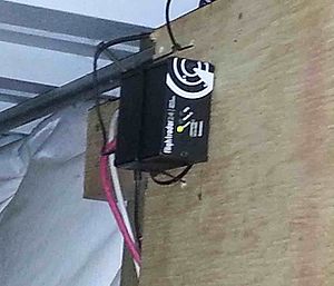
Additionally, there is another mounting board installed here for attaching infrastructure equipment for the WiFi mesh when needed. There is power and an ethernet hub here and this is also where the ADS-B receiver lives.
Radio Projects
ADS-B receiving station
In April 2015 we were notified that our application to receive and host a free ADS-B receiving station for http://www.flightradar24.com/free-ads-b-equipment was approved. The antenna is mounted and the receiver/controller is installed on our network. Members can get our premium login to http://www.flightradar24.com, just email contact at bloominglabs dot org for details.
Downloading aircraft data from our receiver
To download aircraft data from our receiver, use a web browser and connect to the unit (only from within Bloominglabs: http://192.168.1.3 ). There is no login required. You can also use wget to download the full log (goes back about ~36 days):
wget -O aircraft.log http://192.168.1.3/log.php?id=xxx
The data you want are the lines with [mlat] tags in them, in this case A4E330 is the planes id:
2017-07-02 05:49:00 | [mlat][i] A4E330
Log dates are in UTC, so subtract 4 hours to convert all timestamps to EDT (or -5 hours for EST).
Notes on data
Our receiver regularly pulls in beacons from aircraft over 200 nautical miles away. Technically most of the aircraft data we receive are MLAT beacons (S-mode identifiers) which is different from ADS-B. MLAT signals are usually only receivable from the ground if the aircraft is above 5k-10k feet unless direct line-of-sight was obtained. The S-mode identifier is a 24-bit hex address unique to every aircraft. Not all aircraft have beacons, although after the year 2020 the FAA will require all aircraft to have some type of identifier.
The MLAT / S-mode / ICAO24 identifier will tie to a specific aircraft and tail number. Not all sites have a complete database, so multiple sources can be useful when looking up identifiers. These are handy to use:
- https://www.flightradar24.com/data/aircraft
- http://www.airframes.org - Put the MLAT number in the "ICAO24 address" field
This site is very useful, you can do lookups here and also retrieve flight paths to see everywhere an aircraft has been logged:
We only see occasional beacons from aircraft, so when the beacons pop-up behind it’s last known path, it means it was flying a circle around that area. The path just draws straight lines between beacon locations, so that can be somewhat misleading when a plane is circling an area.
Scanner Icecast internet feed
In April 2015 we revieved a Uniden 996T Digital Scanner on long-term loan by a very generous member of the public. This is a top end scanner that can receive the P25 digital mode used by our local emergency services and elsewhere across our state. We have an Icecast server to stream a feed from this radio so members can listen in remotely.
There are a lot of moving parts to get the scanner feed available at the moment. There is a troubleshooting page here for reference: Scanner.
WiFi Mesh - pending
We have two 24dBi 2.4GHz dishes for linking up nearby remote buildings. We have one dish up and pointed towards our first candidate site, we continue to make forward progress.
There are a couple of goals, but the project has room for growth and change. Firstly it would be nice just to see what other sites we can link together to have a private network that spans further than just our building. Second, it could provide backup communication in the event of an emergency. Third, it will be fun just to see what other uses we can come up with for this.
Part 15 station - Bloominglabs Radio - pending
This is essentially a low power non-licensed (legal) broadcast station in the AM commercial band (can be received on any common AM radio). Part 15 refers to 47 CFR 15.221 (Operation in the band 525-1705 kHz in this case).
I've operated these in the past and they are a lot of fun. The coverage area can usually have a radius of about 1 mile, output power is limited to 100mA along with a limit of a 10' antenna. Because of FCC rules and the way this band of radio works the mast MUST be mounted directly into the ground, attaching it to our building will not work. Once our back parking lot area becomes more free of trailers I would like to run coax out through a drain pipe and get a station running.
SatNOGS Ground Station - pending
A couple of us are trying to build a SatNOGS Ground Station. Once this is operational we will be able to contribute to the SatNOGS network and allow members to control the dish for any satellite telemetry work they wish to do.
QR code URL
The latest version of this document is always available online.
http://www.bloominglabs.org/index.php/Radio_Activities


